
Mid-afternoon
After eighteen hours of travel and a tangle with the big city, I was finally on a bus heading for where the birds are. I tried to unwind a little as I sat in the last available seat in the back of the bus, balancing my pack in the aisle. This was my first experience with Latin American public transport, having only rented a car on my trip to Mexico a year and a half ago. This bus was dark, with many of the curtains drawn against the midafternoon sun. The guy next to me, who looked about my age, luckily decided to keep the window and shade open, giving me a view of the ride. He even tried to strike up conversation, an effort which quickly failed as soon as I opened my mouth and garbled a response. He dozed off and I enjoyed the ride.
We wound quickly out of the downtown area and I got my first feel for the Central Valley terrain - it's not flat. From the city it's hard to get a feel for the area, other than the fact that there are mountains and volcanoes in nearly every direction. Moving outward from downtown, the narrow twisty city streets transition to narrow, twisty suburb streets crossing deep wooded ravines and winding through smaller and smaller neighborhoods. The coils of razor wire are replaced by tall iron fencing, and then by living fences as we make the transition from urban to rural. Moving north out of San Jose to cross the Cordillera Central range, this transition happens startling quickly. Twenty minutes out of the city, we were in the rural foothills. In less than thirty minutes we were entering Parque Nacional Braulio Carrillo.
Braulio Carrillo is a huge, virgin tract of land across the Cordillera Central, stretching from La Selva in the north to Volcan Irazu near San Jose. It was created to offset the building of Highway 32 across the range to connect San Jose with the Caribbean coast. Access is limited to several ranger stations, two of which reside on the highway, the others in more remote areas to the north. The highway winds up from San Jose and crosses over the Cordillera Central in the dip between Volcan Barva and Volcan Irazu. The most popular access point for birders is the Quebrada Gonzalez station, on the highway very close to the Caribbean slope border of the park.

(Source: Taylor 2003)
There are only about three kilometers total of trail at Quebrada Gonzalez - not very many for four days of exploration. My hopes were buoyed by the older of the two birding guides I found. The older guide, Taylor (1993), showed many more older trail systems in the park (see map above). The newer guide, Sekarak, and the Lonely Planet guide only really mention Quebrada Gonzalez. All of the guides mention increasing amounts of roadside robberies due to the proximity to the highway and San Jose, so the decreased emphasis on trails away from the ranger stations seemed understandeable. I figured that, if I couldn't hire a range to drop me off at one of the longer trails, where I could hike well away from the road, then I would just loop out to the Barva station on the west side of the park where there are more trails, far from any major road. My main goal in birding Braulio, however, was definitely the Caribbean lowland slope bird fauna, a distinct avifauna I would not have access to anytime later in the trip. So, to Quebrada Gonzalez, the lowest point in the park along the highway, it was.
The highway wound rapidly up into the hills until we passed the park border and through the Zurqui tunnel, through a ridge and the highest point on the highway. The road was bordered here by incredibly steep, vegetation-laden cliffs. Seeing that wall of diverse vegetation (including epiphytes, bromeliads, ferns and many more plants that I don't even know), I first truly felt I was in the tropics. Visibility was reduced after passing through the tunnel as we crossed to the Caribbean slope and its heavier cloud cover. We passed the Zurqui station, which didn't look very inviting to the hiker. The station looked like it perched precariously next to the road, with impossibly steep slopes above and quite a descent below. Perhaps the quick glimpse from the road was deceiving, the guides say there are at least a few trails there. Some mention steep hikes.
The next thirty minutes were spent slowly winding down from the cloud forest to the Caribbean lowlands below. The road twisted and wound along the sides of ridges, ducked back and forth between different river valleys as we made the slow descent. The clouds occasionally parted to reveal brief vistas of unbroken forested hills. It was all too soon (yet not soon enough) when we crossed the bridge over the flat valley of the Rio Sucio and reached the Quebrada Gonzalez station, and passed it on by. I began to panic again, grabbing at my bags and started to move to get the drivers attention. He must have just needed more room to pull off, though, as he did so a little ways down the road but still within sight of the station gate. I hollered a gracias his way and jumped out the back door with my packs. Hoisting my ridiculously heavy frame pack on, I trudged rapidly up the ditch back to the station gate as buses and trucks whizzed by on the highway.
The Quebrada Gonzalez station seemed a lot nicer than what I could see of the Zurqui station we passed earlier. Set back from the road, the station is nestled in the ravine of the creek that is its namesake. There is a short road up, a ticket stand, picnic tables and signs, a lush bromeliad-covered fountain, and several green station buildings. The hills on either side of the ravine loomed up around the station, and across the highway the forest led down to the flat river valley of the Sucio. It seemed like it could be quite a cozy place for a few days of birding if you learn to ignore the highway noise.
I walked up to the empty ticket booth, dropped my pack, and looked out of place until a guard came over from the station. The ranger, Sergio, seemed a little confused at my entrance to the park so late in the afternoon (after 3:30, when the park closes at 4). I began to explain that I wanted four nights when Sergio ruined my already poor day: No hay camping aqui.
I fumbled some spanish as I tried to figure out where I went wrong, and my mind raced to figure out what this would mean for the next few days, and most importantly, for tonight. The confusion emanating from me was enough for Sergio to head over to the station and return with an english-speaking Andrea. I explained my situation - I came here based on these guidebooks to bird. This oldest one, Taylor, says one can stay here. The others don't explicitly say you can't stay here. On account of my plight, and the late hour meaning it would be difficult to flag a bus and find a home for the night, Andrea graciously decided to let me camp for this one night. She directed me to a covered platform in the woods on the main trail where some students studying macroinvertebrates in the creek were camping.
I gratefully thanked Andrea and Sergio and walked a short way up the Sendero Palmas as directed and found the platform in the woods. It was a large square concrete platform with a tin roof. Most of it was taken up with tents and equipment from the (absent) students, but I found a corner with enough room to pitch my own tent. I dropped my stuff and headed out to bird for the rest of the afternoon.

I continued up the Palmas trail, which winds uphill parallel to the Quebrada. At 4:15 in the afternoon, the trail was largely quiet. A short distance uphill, I came across a small wooden mirador (overlook) that provided a view over the Quebrada and the far slope. I tried to spish in a skulking chip-note next to the overlook, and was overwhelmed when I pulled in a small mixed flock. At least half the flock moved rapidly past the overlook, not even giving me a chance to see them. What I did manage to identify in the less than two minutes the flock was present:
1 nonbreeding adult Chestnut-sided Warbler (Dendroica pensylvanica: Parulidae)
* 1 male White-shouldered Tanager (Tachyphonus luctuosus: Thraupidae)
* 1 male Tawny-crested Tanager (Tachyphonus delatrii: Thraupidae)
* 1 male Tawny-capped Euphonia (Euphonia anneae: Fringillidae)
1 Wedge-billed Woodcreeper (Glyphorhynchus spirurus: Furnariidae)
Best of all, though, was the 10-second look I got at my first-ever species of Tangara, a speciose radiation of small tanagers that sport a dazzling array of colors. I spotted the *Emerald Tanager (Tangara florida: Thraupidae) foraging in the interior of a nearby bush, where its brilliant green was subdued by shadow and it blended in quite well. I managed one quick shot before it too flew off with the flock moving rapidly along the Quebrada slope.

After that brief whirlwind of activity, the next half an hour was near to dead quiet. I continued uphill on the trail and heard nothing but a few distant unidentifiable calls. At one point I followed some high squeaky notes and was able to spish out another male Tawny-crested Tanager. It frequently kept its little crown (hardly a crest) raised, displaying a pale tawny crown patch, paler than that depicted in the new Garrigues and Dean guide. A second individual remained secretive, and the brief glimpses I got suggested it was the browner female.
By 5, not seeing anything, I decided to turn back and make camp before it got dark. On the way back downhill I stopped again at the mirador. Several birds were making quite a chattering fuss on the far slope, and were revealed as a group of 3 Band-backed Wrens (Campylorhynchus zonatus: Troglodytidae) when they flew across the ravine to my side.
I made it back to the platform, where the students had returned and were cooking dinner. I introduced myself and my situation, and they helped make sure I had enough room to pitch my own tent and such. None of the three students spoke English, so conversation was unfortunately limited. They seemed like an interesting group.
 After I got myself set up and was munching on some bread and jam, a wren belted out a song close to the platform. I couldn't find it in the fading light, but it was clearly a Thryothorus song pattern of repeated rolling phrases, like our Carolina Wren. I would have to track it down in the morning. By 6pm, it was dusk, and the students set out a blacklight sheet across one of the platform's railings. I wanted to join them, but I was simply too exhausted from the last 24 hours. I briefly considered doing some owl calling, but a heavy downpour rolled in that nixed all night hike plans. I was grateful to have the tin roof of the platform over me. I decided to get to sleep, even though it was not much after 6.
The students sat around talking for several more hours. I listened to their conversations with only partial comprehension. The rain continued all night, drumming away. I thought about where I would go when my time at Braulio was up tomorrow. Late in the night, a chill set in. I waited for the pre-dawn gray.
============================================================
* = lifer!
Previous post: The fine art of poor planning
Next post:
References
Garrigues, Richard and Robert Dean. 2007. The Birds of Costa Rica.
Lonely Planet Costa Rica
Sekarak, Aaron D. 1996. A Travel and Site Guide to Birds of Costa Rica.
Taylor, Keith. 1993. A Birder's Guide to Costa Rica.
We wound quickly out of the downtown area and I got my first feel for the Central Valley terrain - it's not flat. From the city it's hard to get a feel for the area, other than the fact that there are mountains and volcanoes in nearly every direction. Moving outward from downtown, the narrow twisty city streets transition to narrow, twisty suburb streets crossing deep wooded ravines and winding through smaller and smaller neighborhoods. The coils of razor wire are replaced by tall iron fencing, and then by living fences as we make the transition from urban to rural. Moving north out of San Jose to cross the Cordillera Central range, this transition happens startling quickly. Twenty minutes out of the city, we were in the rural foothills. In less than thirty minutes we were entering Parque Nacional Braulio Carrillo.
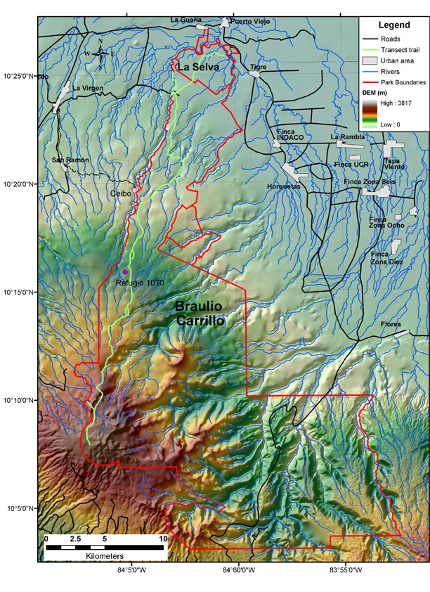
Braulio Carrillo is a huge, virgin tract of land across the Cordillera Central, stretching from La Selva in the north to Volcan Irazu near San Jose. It was created to offset the building of Highway 32 across the range to connect San Jose with the Caribbean coast. Access is limited to several ranger stations, two of which reside on the highway, the others in more remote areas to the north. The highway winds up from San Jose and crosses over the Cordillera Central in the dip between Volcan Barva and Volcan Irazu. The most popular access point for birders is the Quebrada Gonzalez station, on the highway very close to the Caribbean slope border of the park.

(Source: Taylor 2003)
There are only about three kilometers total of trail at Quebrada Gonzalez - not very many for four days of exploration. My hopes were buoyed by the older of the two birding guides I found. The older guide, Taylor (1993), showed many more older trail systems in the park (see map above). The newer guide, Sekarak, and the Lonely Planet guide only really mention Quebrada Gonzalez. All of the guides mention increasing amounts of roadside robberies due to the proximity to the highway and San Jose, so the decreased emphasis on trails away from the ranger stations seemed understandeable. I figured that, if I couldn't hire a range to drop me off at one of the longer trails, where I could hike well away from the road, then I would just loop out to the Barva station on the west side of the park where there are more trails, far from any major road. My main goal in birding Braulio, however, was definitely the Caribbean lowland slope bird fauna, a distinct avifauna I would not have access to anytime later in the trip. So, to Quebrada Gonzalez, the lowest point in the park along the highway, it was.
This map shows Volcan Barva in the lower left, and the highway through the bottom center of the park (black line). Quebrada Gonzalez is near the northern border of the park on the highway.
The highway wound rapidly up into the hills until we passed the park border and through the Zurqui tunnel, through a ridge and the highest point on the highway. The road was bordered here by incredibly steep, vegetation-laden cliffs. Seeing that wall of diverse vegetation (including epiphytes, bromeliads, ferns and many more plants that I don't even know), I first truly felt I was in the tropics. Visibility was reduced after passing through the tunnel as we crossed to the Caribbean slope and its heavier cloud cover. We passed the Zurqui station, which didn't look very inviting to the hiker. The station looked like it perched precariously next to the road, with impossibly steep slopes above and quite a descent below. Perhaps the quick glimpse from the road was deceiving, the guides say there are at least a few trails there. Some mention steep hikes.
Zurqui Tunnel

The next thirty minutes were spent slowly winding down from the cloud forest to the Caribbean lowlands below. The road twisted and wound along the sides of ridges, ducked back and forth between different river valleys as we made the slow descent. The clouds occasionally parted to reveal brief vistas of unbroken forested hills. It was all too soon (yet not soon enough) when we crossed the bridge over the flat valley of the Rio Sucio and reached the Quebrada Gonzalez station, and passed it on by. I began to panic again, grabbing at my bags and started to move to get the drivers attention. He must have just needed more room to pull off, though, as he did so a little ways down the road but still within sight of the station gate. I hollered a gracias his way and jumped out the back door with my packs. Hoisting my ridiculously heavy frame pack on, I trudged rapidly up the ditch back to the station gate as buses and trucks whizzed by on the highway.
The Quebrada Gonzalez station seemed a lot nicer than what I could see of the Zurqui station we passed earlier. Set back from the road, the station is nestled in the ravine of the creek that is its namesake. There is a short road up, a ticket stand, picnic tables and signs, a lush bromeliad-covered fountain, and several green station buildings. The hills on either side of the ravine loomed up around the station, and across the highway the forest led down to the flat river valley of the Sucio. It seemed like it could be quite a cozy place for a few days of birding if you learn to ignore the highway noise.
I walked up to the empty ticket booth, dropped my pack, and looked out of place until a guard came over from the station. The ranger, Sergio, seemed a little confused at my entrance to the park so late in the afternoon (after 3:30, when the park closes at 4). I began to explain that I wanted four nights when Sergio ruined my already poor day: No hay camping aqui.
I fumbled some spanish as I tried to figure out where I went wrong, and my mind raced to figure out what this would mean for the next few days, and most importantly, for tonight. The confusion emanating from me was enough for Sergio to head over to the station and return with an english-speaking Andrea. I explained my situation - I came here based on these guidebooks to bird. This oldest one, Taylor, says one can stay here. The others don't explicitly say you can't stay here. On account of my plight, and the late hour meaning it would be difficult to flag a bus and find a home for the night, Andrea graciously decided to let me camp for this one night. She directed me to a covered platform in the woods on the main trail where some students studying macroinvertebrates in the creek were camping.
I gratefully thanked Andrea and Sergio and walked a short way up the Sendero Palmas as directed and found the platform in the woods. It was a large square concrete platform with a tin roof. Most of it was taken up with tents and equipment from the (absent) students, but I found a corner with enough room to pitch my own tent. I dropped my stuff and headed out to bird for the rest of the afternoon.

I continued up the Palmas trail, which winds uphill parallel to the Quebrada. At 4:15 in the afternoon, the trail was largely quiet. A short distance uphill, I came across a small wooden mirador (overlook) that provided a view over the Quebrada and the far slope. I tried to spish in a skulking chip-note next to the overlook, and was overwhelmed when I pulled in a small mixed flock. At least half the flock moved rapidly past the overlook, not even giving me a chance to see them. What I did manage to identify in the less than two minutes the flock was present:
1 nonbreeding adult Chestnut-sided Warbler (Dendroica pensylvanica: Parulidae)
* 1 male White-shouldered Tanager (Tachyphonus luctuosus: Thraupidae)
* 1 male Tawny-crested Tanager (Tachyphonus delatrii: Thraupidae)
* 1 male Tawny-capped Euphonia (Euphonia anneae: Fringillidae)
1 Wedge-billed Woodcreeper (Glyphorhynchus spirurus: Furnariidae)
Best of all, though, was the 10-second look I got at my first-ever species of Tangara, a speciose radiation of small tanagers that sport a dazzling array of colors. I spotted the *Emerald Tanager (Tangara florida: Thraupidae) foraging in the interior of a nearby bush, where its brilliant green was subdued by shadow and it blended in quite well. I managed one quick shot before it too flew off with the flock moving rapidly along the Quebrada slope.
Emerald Tanager! Note the distinct black ear patch.

After that brief whirlwind of activity, the next half an hour was near to dead quiet. I continued uphill on the trail and heard nothing but a few distant unidentifiable calls. At one point I followed some high squeaky notes and was able to spish out another male Tawny-crested Tanager. It frequently kept its little crown (hardly a crest) raised, displaying a pale tawny crown patch, paler than that depicted in the new Garrigues and Dean guide. A second individual remained secretive, and the brief glimpses I got suggested it was the browner female.
By 5, not seeing anything, I decided to turn back and make camp before it got dark. On the way back downhill I stopped again at the mirador. Several birds were making quite a chattering fuss on the far slope, and were revealed as a group of 3 Band-backed Wrens (Campylorhynchus zonatus: Troglodytidae) when they flew across the ravine to my side.
I made it back to the platform, where the students had returned and were cooking dinner. I introduced myself and my situation, and they helped make sure I had enough room to pitch my own tent and such. None of the three students spoke English, so conversation was unfortunately limited. They seemed like an interesting group.
 After I got myself set up and was munching on some bread and jam, a wren belted out a song close to the platform. I couldn't find it in the fading light, but it was clearly a Thryothorus song pattern of repeated rolling phrases, like our Carolina Wren. I would have to track it down in the morning. By 6pm, it was dusk, and the students set out a blacklight sheet across one of the platform's railings. I wanted to join them, but I was simply too exhausted from the last 24 hours. I briefly considered doing some owl calling, but a heavy downpour rolled in that nixed all night hike plans. I was grateful to have the tin roof of the platform over me. I decided to get to sleep, even though it was not much after 6.
The students sat around talking for several more hours. I listened to their conversations with only partial comprehension. The rain continued all night, drumming away. I thought about where I would go when my time at Braulio was up tomorrow. Late in the night, a chill set in. I waited for the pre-dawn gray.
============================================================
* = lifer!
Previous post: The fine art of poor planning
Next post:
References
Garrigues, Richard and Robert Dean. 2007. The Birds of Costa Rica.
Lonely Planet Costa Rica
Sekarak, Aaron D. 1996. A Travel and Site Guide to Birds of Costa Rica.
Taylor, Keith. 1993. A Birder's Guide to Costa Rica.


"No hay camping aqui"!! Wow, what an adventure you are having, although great birds! Can't wait to hear what next could happen to you! Thanks for sharing such a long in depth post!
ReplyDeleteI wish I was able to go on a trip like the one posted up on top! Wow Thailand is the place to be! You know what.. Im gonna plan to go there in this summer! Thats it I made my mind..
ReplyDelete-Kelly